AlphaEarth Foundations: DeepMind AI with a Detailed View of Earth
Satellites continuously collect vast amounts of data about Earth, from imagery to measurements that provide experts with up-to-date information on the state of the planet. However, this data is often complex, diverse, and rapidly changing, making it difficult to use to its full potential. This is where AlphaEarth Foundations, an advanced artificial intelligence model from Google DeepMind, comes into play. This system acts as a virtual satellite, combining petabytes of Earth observation information into a single unified digital form known as an embedding. This enables computers to process data easily and provides scientists with a more comprehensive view of how the planet is evolving. The result? Better decisions in areas such as food security, combating deforestation, urban growth, and water resource management.
This model accurately depicts Earth's entire landmass and coastal areas by integrating various types of data. To support research and practical applications, the team released annual embeddings in Google Earth Engine. Over the past year, they collaborated with more than 50 organizations that tested this data in real-world scenarios. Partners appreciate how it helps them better identify unknown ecosystems, track changes in agriculture and the environment, and improve both the accuracy and speed of map creation.
How AlphaEarth Foundations Works
AlphaEarth Foundations addresses key challenges in working with geospatial data: too much information and inconsistencies between datasets. It first collects data from many public sources, such as optical satellite imagery, radar data, 3D laser maps, climate models, and more. It combines all these elements into an analysis that divides the world into small squares measuring 10x10 meters. This makes it possible to track changes over time in great detail and with high accuracy.
Another major advantage is the creation of compact summaries for each square. These summaries take up 16 times less space than those produced by other AI systems tested, significantly reducing the cost of large-scale analyses. Scientists can thus create accurate maps on demand—for example, to assess crop conditions, monitor forest cover, or track new construction. They no longer have to wait for a specific satellite; they have a robust foundation for all geospatial tasks.
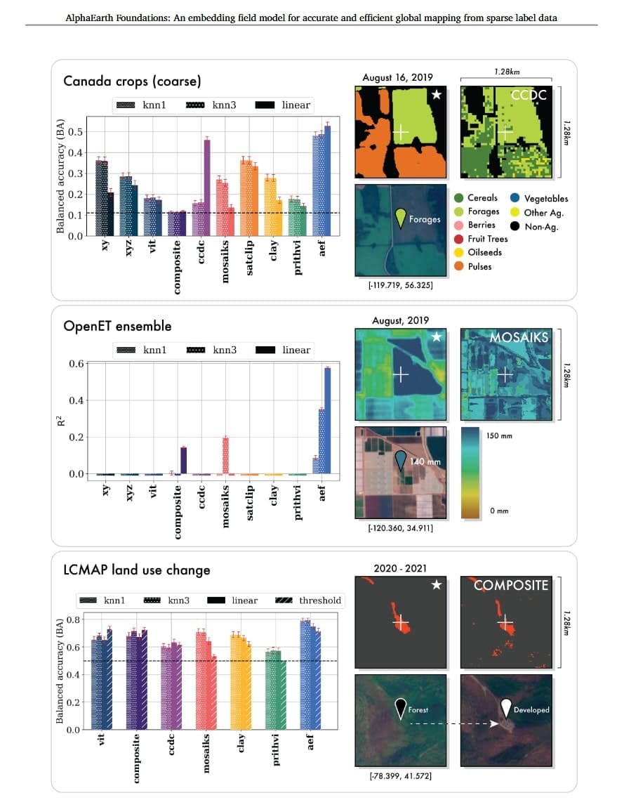
The team thoroughly evaluated the model in tests. Compared with conventional approaches and other AI tools, it proved to be the most accurate across various tasks, such as determining land use or estimating surface characteristics. It performed particularly well when little labeled data was available, with an average error rate 24% lower than its competitors. Details can be found in their study on arXiv.
Custom Maps with the Satellite Embedding Dataset
Powered by AlphaEarth Foundations, the Satellite Embedding dataset in Google Earth Engine offers more than 1.4 trillion embedding elements annually—one of the largest collections of its kind. Organizations such as the Food and Agriculture Organization of the United Nations (FAO), Harvard Forest, Group on Earth Observations, MapBiomas, Oregon State University, Spatial Informatics Group, and Stanford University use it to create specialized maps that provide practical insights.
One example is the Global Ecosystems Atlas project, which aims to create the first comprehensive overview of the world's ecosystems. Using this dataset, the project helps countries classify previously unknown areas into categories such as coastal shrublands or hyper-arid deserts. This is essential for setting nature conservation priorities, planning restoration, and combating biodiversity loss.
Nick Murray, director of the Global Ecology Lab at James Cook University and scientific lead of the Global Ecosystems Atlas, noted: "This dataset fundamentally transforms our work by enabling countries to map previously unknown ecosystems—this is crucial for targeting conservation measures."
In Brazil, MapBiomas is testing the data to better understand changes in agriculture and the environment. Such maps support sustainable development strategies in places like the Amazon rainforest. Tasso Azevedo, founder of MapBiomas, added: "This dataset could completely transform our approach—we can now create maps that are more accurate, more detailed, and completed faster, which was previously unimaginable."
The Future with AlphaEarth Foundations
This model represents a major advance in understanding the dynamics of our planet. It is currently used to create annual embeddings, but the team sees potential in combining it with advanced systems such as Gemini for even better analyses. They continue to develop temporal capabilities as part of Google Earth AI, a collection of models and data designed to address global challenges.
The project was created through collaboration between the Google DeepMind and Google Earth Engine teams, with contributions from experts including Christopher Brown, Michal Kazmierski, Valerie Pasquarella, William Rucklidge, Masha Samsikova, Olivia Wiles, Chenhui Zhang, Estefania Lahera, Evan Shelhamer, Simon Ilyushchenko, Noel Gorelick, Lihui Lydia Zhang, Sophia Alj, Emily Schechter, Sean Askay, Oliver Guinan, Rebecca Moore, Alexis Boukouvalas, and Pushmeet Kohli.